


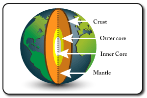
Structure of the Earth
- The crust is the outer layer, broken into sections caled tectonic plates. It is the thinnest layer.
- The mantle is the thickest layer and consists of molten rock
- The outer core is molten & about 3000 degrees C.
- This inner core is solid due to the immense pressure and is about 5000 degrees C.
- Both the inner & outer core consist of iron & nickle.
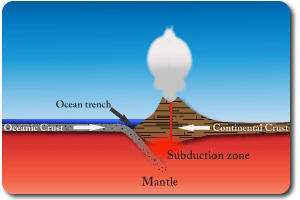
Destructive Boundary
- Oceanic & continental plates collide. The oceanic plate is denser and so sinks under the continental plate.
- As the oceanic plate sinks it takes some sand, water and other materia from the sea bed with it. This melts and is gaseous which causes it to force its way up to the surface as a volcano.
- The continental plate crumples at the edge creating fold mountains in addition to the volcanoes.
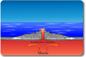
Constructive Boundary
- Convection currents in the mantle drag the plates apart.
- Magma rises to fill the gap and solidifies to form new crust.
- As the process repeats a ridge is formed and this slowly gets wider as the plates continue to seperate.
- Example: the Mid-Atlantic Ridge.
- This creates fissure volcanoes which are long cracks, they are less explosive.
Collision Boundary
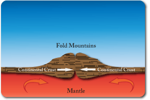
- Convection currents in the mantle pull two plates of continental crust together.
- Since both crusts are made of the same material and have equal density neither subducts. They crumple up.
- This process creates fold mountains. There are no volcanoes at these boundaries but earthquakes occur.
- Example: the Himalayas.
Volcanic Structures
- Volcanoes vary in shape and structure depending on the reason for their existence.
- Destructive boundary volcanoes are often cone shaped and explosive.
- Constructive boundary volcanoes are often more gently sloped and have less violent erruptions.
- Lava, ash, cinders and smoke may be ejected from the vent.
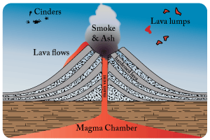
Types of Volcano
- Shield: gentle sloping, created by basic lava (travels along way before solidifying). Found at constructive boundaries.
- Composite: alternating layers of acid lava & rock/ash create the classic conical shape. Found at destructive boundaries.
- Ash & cinder: Alternating layers of ash & cinder compacted.
- Fissure: volcanoes running along a crack in the crust, usually a constructive boundary.
- Caldera: Crater volcano created after volcano collapses in on itself having emptied the magma chamber.
- Dome: steep sided volcano created by acid lava which cools before it has travelled far.
Why People Live Near Volcanoes
- Fertile land: excellent for farming.
- Water supply: reliable water supply from snow melt or relief rainfall.
- Tourism: jobs in tourist Industry (hotels, guides, shops).
- Unaware: didn’t realise that the mountain was actively volcanic.
- Cheap land: can’t afford to move/get a job elsewhere.
- Resources: sulphur & other minerals can be mined here.
Predicting Erruptions
- Tilt meters: detect any changes in the angle of the volcanoes slopes.
- Satellite imagery: allows views inside the crater and to monitor changes in the shape of the volcano.
- Gas samples: scientists measure the gases coming out of the volcano. Changes which indicate it is becoming more active.
- Seismometers: measure vibrations in the ground which indicate movement.
Earthquake Features
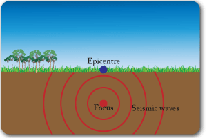
- The focus is the exact point at which the earthquake occurred which could be below an ocean and deep in the crust.
- The epicentre is the point on the earth’s surface directly above the focus.
- Seismic waves spread out from the focus. The further they travel the weaker they become.
- The depth of the focus has a significant impact on the strength of the earthquake at the earths surface.
Measuring Earthquakes
- Seismologists are people who study earthquakes.
- A seismometer is used to measure the magnitude of any vibrations in the earth’s crust.
- A seismograph displays the information.
- The Richter Scale is a logarithmic scale which measures the magnitude/energy realised in a quake.
- The Mercalli Scale measures the damage caused by a quake.
Predicting Earthquakes
- Monitoring gases for an increase in the levels of radon.
- Lasers and creep meters can be used to detect small movements at fault lines.
- Seismometers detect any vibrations which could indicate a earthquake is likely to happen.
- Animals often behave strangely before earthquakes occur.
Preparing for Earthquakes
- Planning: emergency service responses, medical, food & water supplies
- Education:Turing off gas appliances Safe points & evacuation drills in buildings. First aid kits & torches at home.
- Building design:
- Cross-braced structures
- Solid & deep foundations
- Emergency exits & sprinkler systems to extinguish fires.
Variations in the Ability to Cope with Earthquakes
- MEDCs generally suffer less than LEDCs from the effects of tectonic disasters.
- This may be partly due to many LEDCs being located in more active areas but a significant factor is the economic resources available to MEDCs.
- Financial ability to strengthen buildings and add features such as water sprinklers for fires.
- Better technology used in building construction.
- More resources and equipement for emergency services when dealing with a disaster.
- More money spent on predicting earthquakes/volcanoes (scientists and technology).
- Larger reserves of emergency food, medicine, water & shelter to cope in an emergency.
- Financial ability to rebuild and repair essentail facilties quickly (hospitals, homes etc).
The ability of MEDCs to prepare and predict more thoroughly reduces the impact of most disasters. The same is true for other natural disasters such as floods and hurricanes.
Links to interactive guides
Mt. St Helens------------Volcanic Eruption---------------18th May 1980
Location: NW America, part of Cascades mountain range.
Cause: Destructive boundary (Juan de Fuca plate sub-ducting below N. American plate).
Effects:
- Landslides of rock, ice & soil filled most of spirit lake.
- Pyroclastic flows killed vegetation and wildlife to the North.
- 61 people killed.
- Floodwaters washed away roads and railway bridges.
- Electricity supplies were interrupted.
- Ash settled on towns , people in Yakima had to wear face masks to go outside.
Kobe---------------------Earthquake--------------------17th January 1995
Location: Southern Honshu, Japan.
Cause: Destructive boundary (Philippines plate sub-ducting under Eurasian plate).
Effects:
- Measured 7.2 on Richter Scale & lasted 20 mins.
- 200 000 building collapsed.
- 1km of Hanshin Expressway (elevated main road) collapsed.
- Fires burned for days (broken gas pipes & wooden houses!!!).
- Severe traffic jams delayed emergency services.
- 5500 people killed. Factories closed (Mitsubishi & Panasonic).
Solutions: Stricter building regulations & improved prediction technology.