Placeholder image

Freshwater: Issues and Conflicts

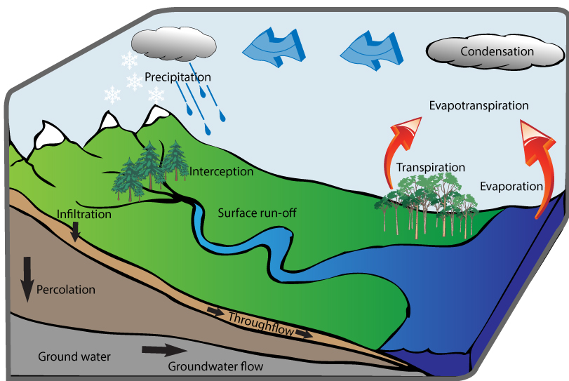
Hydrological Cycle

Water balance: relationship between inputs and outputs of a drainage basin.

Precipitation = Q (runoff/discharge) + E (evapotranspiration) +/- changes in storage.

Tasks

1. Define the different stages in the hydrological cycle:

  • evaporation
  • transpiration
  • condensation
  • precipitation
  • interception
  • infiltration
  • surface runoff
  • throughflow
  • groundwater
  • groundwater flow

2. Identify stores (groundwater, lakes, clouds) and transfers (precipitation, evaporation, throughflow etc).
Placeholder image
Figure A1.1: The Hydrological Cycle

Changing Balance of Ice and Water

Climate change is reducing the volume of water stored as ice.

Tasks

  1. Watch video A1, describe why mountain glaciers are so important for many people and economies.
  2. What are the likely effects of reducing mountain glaciers?
  3. Read this article and describe the concerns of the local Nepalese regarding the glacial lakes forming in the Himalayas
Video A1.1 Melting Mountain Glaciers

Drainage Basin: The area drained by a river and its tributaries.

Drainage Divide: Also known as a watershed, it is the line defining the boundary of a river or stream drainage basin separating it from adjacent basin(s).

You should have an understanding of the following river features:

*source, tributary, confluence, channel, floodplain, mouth, delta, distributaries.

* River profile & characteristics: upper, middle & lower valley. Bradshaw model. Waterfalls.

* River discharge: define, measurement (cumecs).
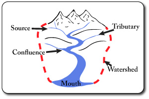
Drainage Basin Features

The Bradshaw Model

Figure A3: Bradshaw model shows how rivers change as they move from the source to the mouth. Study the model and make sure you can explain why some factors increase while others decrease with distance from the source.

River profile & characteristics: upper, middle & lower valley. Bradshaw model. Waterfalls. River discharge: define, measurement (cumecs).

Placeholder image

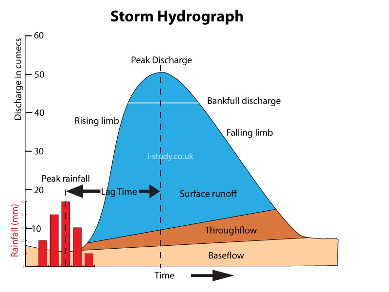
Storm Hydrographs

Tasks

  1. Describe the factors affecting the hydrograph: basin shape/size, drainage density, human influence, slope gradient, climate, soil type, vegetation.
  2. How do these affect the lag time and peak discharge?
  3. Explain the purpose & use of hydrographs in predicting floods and the frequency of occurance of floods.
Placeholder image
Figure A1.2 Storm Hydrograph

Flooding

Pakistan Floods 2010

Flooding is the most obvious and devastating hazard of living close to rivers. Pakistan experienced severe flooding in 2010 that displaced millions of people.

Tasks

  1. Watch Video 2.31 and use these links:Interactive map, about news.
  2. Identify the main physical and human causes of the floods
  3. Describe the main effects of the floods (people, economy, food supplies).
  4. Use this article to describe some of the methods being used to reduce the impact of future floods.

Dams and Reservoirs

Damming the Mekong

Tasks

Open this Guardian article about the Mekong

Create a Case Study about the environmental and human impacts of economic development and the Mekong River:
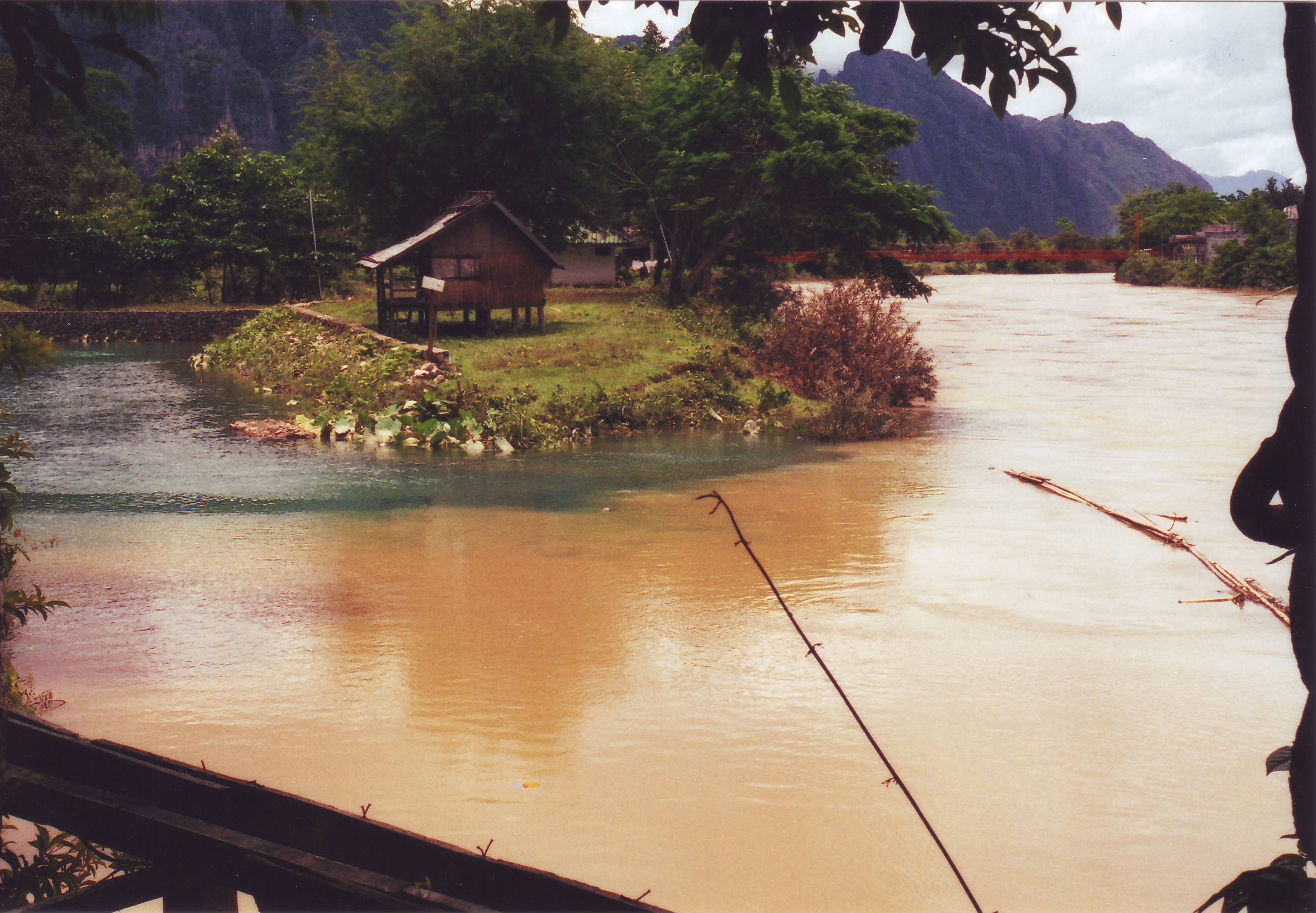
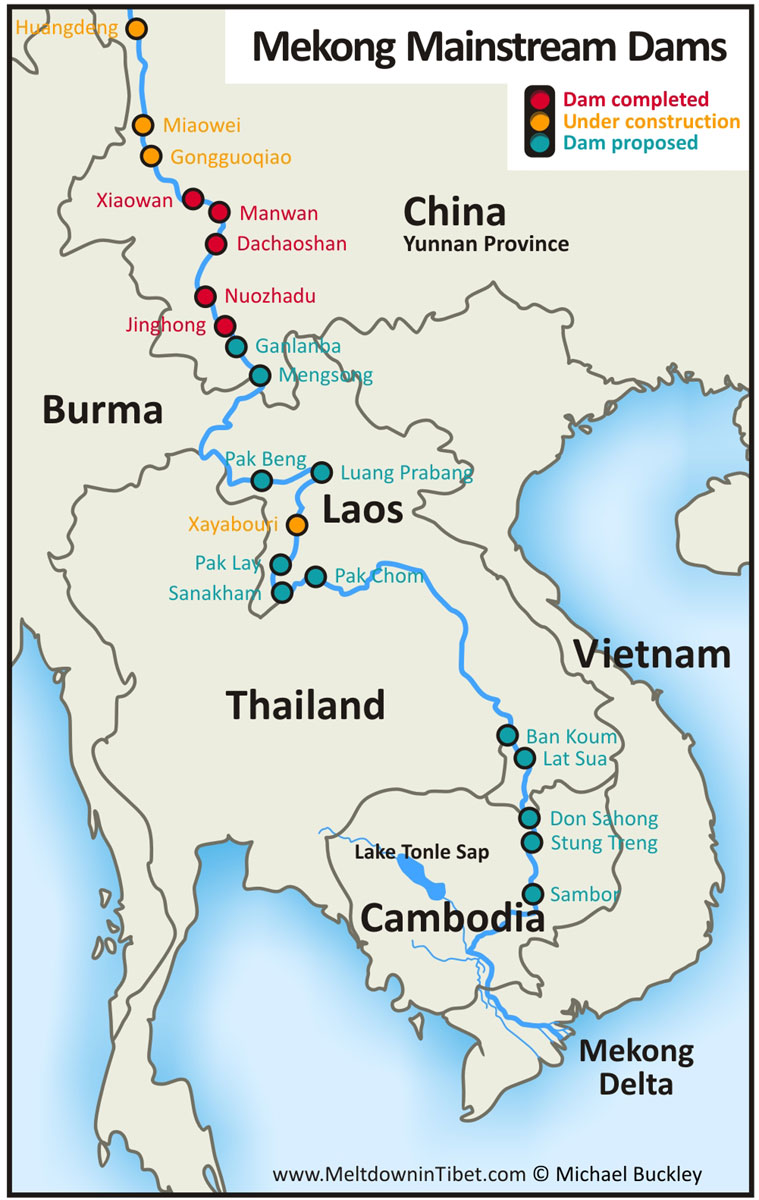
  1. Where is the Mekong (get a map like Figure 1)
  2. When & why did Laos build the Nam Ngum dam?
  3. What was the environmental impact of building this dam?
  4. Why does Laos want to build more dams?
  5. How many dams is it proposing to build over the next 15 years?
  6. What are the negative impacts of dams in general that are mentioned?
  7. What is the human population in the lower Mekong region, relying on the river?
  8. What are the major concerns about the Don Sahong dam?
  9. Why is the the Lower Sesan 2 dam considered the most ecologically damaging?
  10. Explain why the delta is under threat (why is it sinking)?
  11. How much sediment used to reach the sea & how much reaches it now?
  12. Describe the reasons why the sediment load has reduced so drastically.
Placeholder image
Placeholder image
Figure A1.2 Storm Hydrograph (source)

Floodplain Management

Erosion

You should be able to explain where these erosional processes take place eg: attrition and abrasion occur largely in the upper course where the larger more angular rocks scrape and collide when they move.
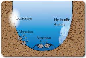
  • Hydraulic Action: pressure/force of the water loosening material & widening cracks in the river bank.
  • Abrasion: the scraping action of material being transported.
  • Attrition: the breaking of stones when they collide with other material.
  • Corrosion: the dissolving of rock (limestone etc) by acid in the water.
Placeholder image
Figure A1:3 Erosion diagram

Transportation

You should be able to describe the changes in the typeof transportation that occur with distance from the source.
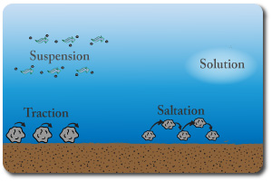
  • Traction: the rolling of stones & rocks. Usually larger rocks.
  • Saltation: stones/rocks bouncing. Usually smaller rocks due to the energy required.
  • Suspension: very small particles being carried along in the river current.
  • Solution: dissolved material (invisible).
Placeholder image
Figure A1:4 Transportation diagram

Groundwater Management

Water Extraction

Maximum Sustainable Yield: Maximum Sustainable Yield: The maximum level of extraction that can be maintained indefinitely for a given area.

Read this article for an introduction to the unit Groundwater. Published by http://www.yearofplanetearth.org/

Tasks

  1. Use p.126 to define groundwater and aquifers.
  2. Watch video A1:2
  3. Describe what groundwater is
  4. What % of freshwater is estimated to to be groundwater
  5. How can it be replenished naturally?
  6. Read this article (Namibia) and describe the importance of discovering groundwater in Namibia and the challenges of extracting it.
  7. Use this article (Bangladesh) and page 126 in the textbook to describe the dangers of polluting groundwater supplies
  8. Use this article (India) and page 127 in your book to describe the impacts of unsustainable groundwater use.
  9. Use Video A1:4 to make short Case Study notes about the impact of groundwater extraction in Holland.
  10. Read the links below:
Video A1:2 Introduction to Groundwater
Video A1:3 Concerns about Groundwater Extraction
Video A1:4 Groundwater Extraction and Sustainability

Freshwater Wetland Management

Case Study: Kissimmee River Restoration

Wetlands: Areas that are regularly saturated by surface water or groundwater, including freshwater marshes, swamps and bogs.

Wetlands are an important ecosystem supporting a wide species diversity. They also filter water passing through them removing many pollutants. In addition they can play a significant role in reducing flood risk.

Many wetland systems around the world are under threat due to development.

Tasks

  1. Watch the videos opposite to make case study notes about the Kissimme river project and restoration. Make sure that you answer the following questions in your notes
    • Where is the Kissimmee river.
    • How, why & when was it altered?
    • Why is it being restored?
    • How is it being restored?
    • What is the financial cost of restoring the wetlands?

Additional Resources:

  1. http://www.theevergladesstory.org
  2. http://www.protectingourwater.org
Video A1:5 Kissimmee River, Part 1
Video A1:6 Kissimmee River, Part 2
Video A1:7 Kissimmee River, Part 3

Irrigation & Agriculture

Eutrophication

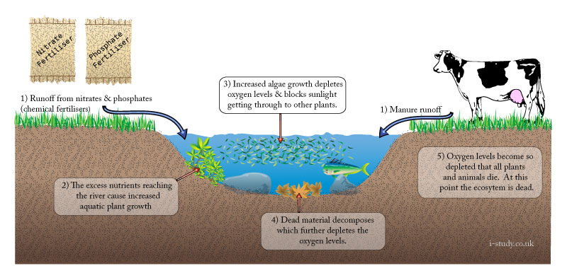
Eutrophication: nutrient enrichment of streams, ponds and groundwater.

Read this article: Fertilisers: Enriching the worlds soil

Tasks
  1. Read & make notes about the the impact on a global scale that fertilisers are having.
  2. Why have they become so essential for food supplies, but also for economies that rely on agriculture?
  3. What is micro-dosing and how can it help overcome?

nitrate pollution & effect in UK

Placeholder image
Figure A1:5 Eutrophication diagram

National Scale Conflict Over Water

Conflict in The Andes, Peru

The Guardian.co.uk - The Andes

Mini-series looking at water shortages in Peru. Watch the 3 videos (A7 to A9).

Tasks

  1. Draw or get a map that shows where the Andes and Peru are.
  2. Make Case Study notes about:
  3. The causes
  4. The effects on the local people - why is there conflict?
  5. Ideas about what can be done.

The Andes: Retreat of the glacier

Water wars come to Peru

Video A1:9: Andes Water Wars 1
Video A1:10: Andes Water Wars 2
Video A1:11: Andes Water Wars 3

International Scale Conflict Over Water

Conflict over the River Nile

The Nile flows through many African countries ending in Egypt at the Nile delta. Egypt is almost completely reliant on the Nile as a source of freshwater due to its desert climate.

Most of the countries it flows through are experiencing rising populations and the need to grow more food. Their economies are slowly industrialising and require more electricity. These factors are resulting in more water being demanded from all the countries which is leading to conflict.

Tasks

  1. Use the links below to make a Case Study about the conflicting demands for water from the River Nile. Include the following sections:
  2. Annotate a map showing the countries that the Nile flows through and why they are potentially requiring more water from the Nile.
  3. Describe the historical agreements over the Niles water.
  4. Why are Ethiopia and Uganda wanting to use more of the Niles water upstream?
  5. Why is Egypt strongly opposed to other countries using more of the water from the Nile.
  6. Do you think that the other African countries should be allowed to take more water from the Nile and to dam it? Support your answer with reasons and examples.

Interactive guide (2010)

The Nile River Basin

Placeholder image
Members area