Coastal Processes, Opportunities and Hazards

Study and revision resources

Placeholder image
Members area

Waves are key to the physical processes occuring in coastal landscapes. The size and energy of waves are determined by the fetch. How strong the wind is and how far the wave has travelled also contribute to the size and energy.

Fetch: the distance of ocean that the wind has been blowing over.

Swash: the movement of a wave up the beach

Backwash: the water from a wave returning to the sea.

Video 5.1: Swash and backwash

Types of Waves

Constructive waves

These waves have a stronger swash than backwash and deposit material on beaches building them up. They are lower in height than destructive waves and also less frequent.

Destructive waves

These waves have a stronger backwash than swash which removes material from beaches. They are steeper, higher and more frequent than constructve waves.

constructive and destructive wave diagram
Fig 5.2 Wave types & characteristics

Types of Coastal Erosion

The erosion process that act upon coasts are the same as those in rivers:

  • Hydraulic action
  • Abrassion
  • Attrition
  • Corrosion

The rate of erosion occurring along coastlines depends upon the type and strength of the waves, but also the type of rock.

Erosion and deposition constantly change coastlines around the world posing many challenges for the communities that live along them.

Coastal erosion
Figure 5.3 Coastal erosion causing collapse of land

Coastal Transportation

Longshore Drift

Material is transported along coastlines due to the direction that in which the waves are travelling.

The swash often comes up the beach at an angle depositing material. The backwash returns directly back to the sea (gravity is acting on it rather than the wind). This process repeatedly moves material along coastlines. The prevailing wind reaching a coastline means that there is usuall a distinctive longterm direction of transportation.

Changes in the wind direction may alter the angle at which the waves approach the coast meaning that the direction of longshore-drift may change temporarily.

Managing Longshore Drift

Groynes made from treated wood are commonly used to slow down the process by trapping the sand as it moves along the beach. These are relatively cheap and can be removed without leaving permanent damage. Concrete blocks/rocks are sometimes used to achieve the same result.

Longshore Drift diagram
Figure 5.4 Longshore Drift Process
wooden groynes
Figure 5.5 Wooden Groynes on the UK Coastline

Headlands and Bays

Areas of softer rock erode more rapidly than bands of hard rock. The result of this uneven erosion is the formation of bays with rocky outcrops of headland at the ends.

Bays can vary significantly in length from a couple of hundred meters to many kilometers.

  1. Draw and label a diagram showing a bay and headland, include labels identifying hard and soft rock.
Bay and headland
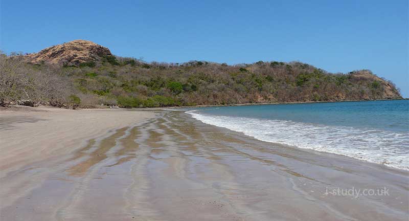
Fig 5.6 Sandy bay with headland; Playa Conchal, Costa Rica

Headland Features

Headlands are exposed to the full force of the waves. As they erode they often form distinctive characteristics.

  1. The hydraulic action of the waves widens cracks in the rock eventually forming caves.
  2. Sand in the waves causes abrasion and eventually the cave may erode completely through the headland to form an arch.
  3. Over time the arch becomes wider until it cannot support the top which collapses leaving a stack.
  4. The base of the stack continues to be eroded until it collapses and leaves a stump.

The Australian southern coast is famous for these landforms, named the 12 apostles.

Headland Features
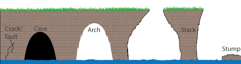
Figure 5.7 Headland characteristics
headland erosion features
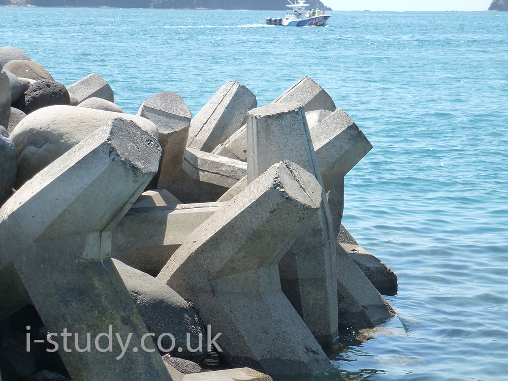
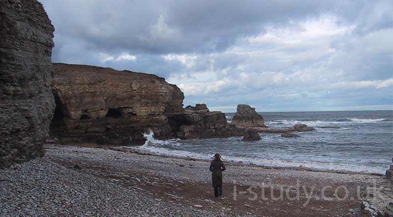
Fig 5.8 Faults, caves, stack and stump: South Shields, UK

Wave Cut Notches and Platforms

Notches

These form along areas of harder rock where the base of cliffs are eroded, undercutting them until sections fall.

The section eroded at the base of the cliff is called a wave cut notch. See Figure 5.9.

Platforms

As this is repeated the cliff retreats leaving a platform of hard rock, often covered at high tide but exposed at low tide. See Figure 5.10

The debris from fallen sections of the cliff is often spread across the platform.

Older wavecut platforms are likely to have a smoother surface with channels where the water returns to the sea. Newer platforms are likely to be uneven and have stumps remaining.

Tasks

  1. Draw and label your own diagram of how erosion leads to wave cut notches.
  2. Draw and label your own diagram showing how wave cut platforms are formed.
  3. Explain why wave cut platforms form along stretches of cliff.
undercut cliff
Figure 5.9 Wave cut notch at low tide: UK
wave cut platform
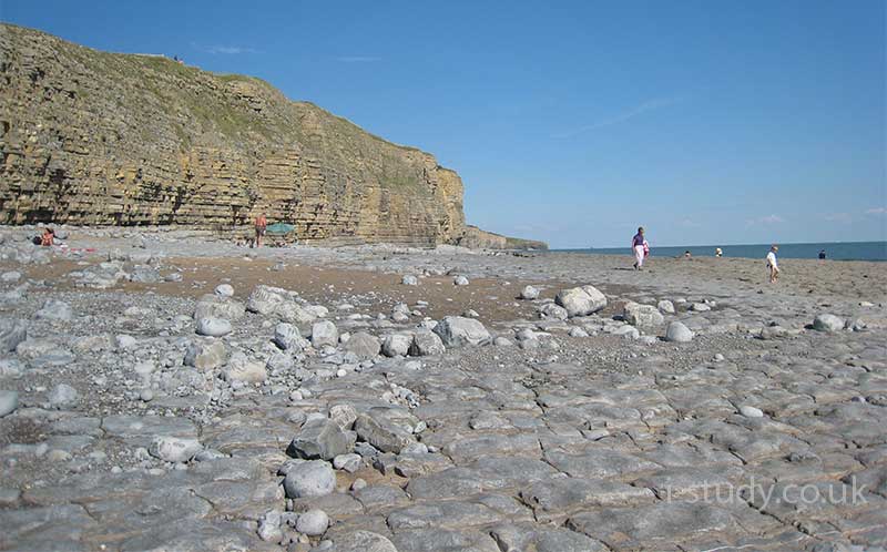
Figure 5.10 Wave cut platform at low tide: UK
wave cut platform and notch diagram
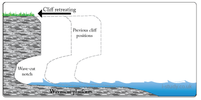
Figure 5.11 Wave cut platform diagram

Depositional Features

In areas where the coastline is sheltered from the full force of the waves the water has less energy and deposits material. Headlands often protect sections of bays from waves coming in at an angle. Deposited material forms distinctive geographical features.

Bars: these are ridges of sand that extend across bays or estuaries blocking them from the sea.

Tombolos: these are bars that stretch out to a nearby island.

Spits: these form at indented sections of coast or besides headlands. They stretch out as a sandy ridge and are often curved at the end due to the effects of changing winds on the wave direction.

Saltmarsh usually forms behind spits as further deposition occurs and grasses start to establish.

coastal bar
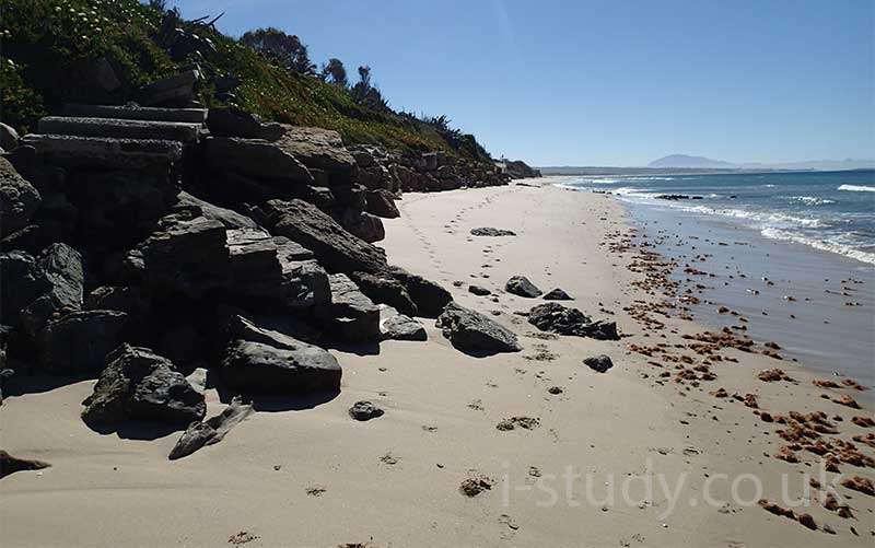
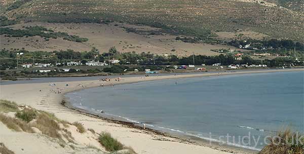
Figure 5.12 Bar, Tariffa, Spain
tombolo
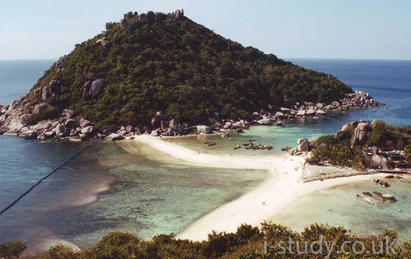
Figure 5.13 Tombolo, Thailand

Sand Dunes

Sand dunes are banks or ridges of sand that form at the back of beaches. They trap sand blown by the wind and gradually increase in size.

Grasses and other vegetation often establish themselves overtime and these help stablise the dunes by trapping the sand. The roots also hold the sand in place. Dunes often gradually change shape and size as sand is continually eroded and deposited.

Sand dunes form an important ecosystem providing a habitat for a range of plant and insect life.

sand dunes
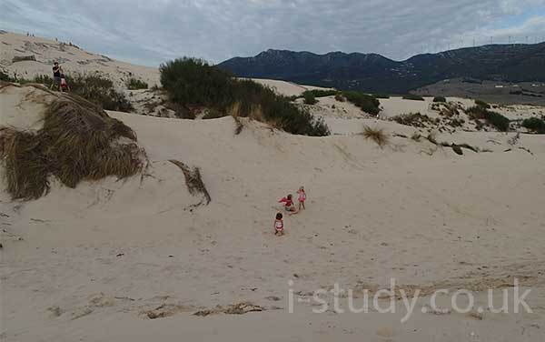
Figure 5.14 Sand dunes, Tarifa, Spain

Coral Reefs

Watch Video 5.1 and use this link (use the subpages in the coral section) to answer the questions.

  1. Describe the environmental importance of coral reefs.
  2. Describe the benefits they have for humans (flood defence, financial).
  3. Explain why coral reefs are increasingly under threat?
  4. Why is coral bleaching (turning white) a bad sign?
Video 5.1 Introduction to Coral

Mangroves

Mangroves play a vital role in coastal ecosystems. They are an essential part of the the natural environment, stabalising sediment, providing a habitat for a diverse range of species. They are also an excellent form of protection against storm surges and tsunamis.

Tasks

Use this link and the other mangrove subpages to answer the following questions.

  1. What is the econmic value of mangroves?
  2. Describe their value in the following areas:
    • Fisheries
    • Timber and plants
    • Coastal protection
    • Tourism
  3. Describe the main threats to mangrove forests.
mangrove roots
Figure 5.15 Mangrove roots, Tanzania
mangroves
Figure 5.16 Established mangrove, Quepos, Costa Rica

Coastal Opportunities

Coastal zones make up only 10% of the ocean environment, but are home to over 90% of all marine species. Of the 13,200 known species of marine fish, almost 80% are coastal.

Beaches

  1. Describe the opportunities that coastal locations provide in terms of the tourism industry. Use the Costa Del Sol as an example (video 5.1)
  2. Mention the industries that support the obvious tourist related jobs.

Coral Reefs

  1. Read this article and describe the opportunities that coral reefs provide for coastal communities

Fishing

  1. Describe the importance of fishing for coastal communities, especially in developing countries (video 5.2).
  2. Coastal fishing requires low levels of capital and education . Explain what this means and why it is an important factor for LEDCs?
Video 5.1 Tourism in the Costa del Sol
Video 5.2 Indonesian Fishermen

Coastal Hazards

Coastal environments present hazards for people living along them. One of the major hazards is the risk of flooding due to high tides or storm surges.

Hurricane Sandy (2012)

Watch the 1st video which looks at the impacts of hurricane Sandy on the New Jersey coastline in the USA.

50 images of hurricane Sandy

  1. Describe the effects of the storm surges.
  2. Read this article and describe the proposal to protect Manhattan from future storm surges.

Hurricane Katrina (2005)

Watch the first 5 mins of 2nd video

  1. Make notes about the effects of hurricane Katrinas storm surge.
  2. Why was New Orleans so vulnerable to the hazard of storm surges?
Video 5.3 Hurricane Sandy Storm Surge
Video 5.4 Impacts of Hurricane Katrina

Hard Engineering

Rock Armour

Rock armour is the use of large boulders or rocks that are placed at the bottom of cliffs or sand dunes to absorb the energy of the waves and protect the land behind.

It is a relatively cheap method of protection since local materials can be used. The rock armour can be quite easily removed in the future leaving little impact.

Gabions

These are wire cages filled with rock/pebbles/shingle and perform the same function. Again they are relatively cheap since they can be assembled at the location they are to be used in. Local material can be used to fill the cages and they can also be removed easily at a later date.

Beach rock armour
Figure 5.18 Rock Armour, Spain
rock armour
Fig 5.17 Rock armour protecting the coast: Southern Spain
concrete rock armour
Fig 5.18 Concrete armour protecting the coast: Costa Rica

Soft Engineering

Managed Retreat

One method of managing coastlines is to let the sea reclaim protected land and allow nature to determine the changes.

Watch the first video opposite and answer the following:

  1. What is the purpose managed retreat (how does it work)?
  2. What are the costs of allowing the land to be flooded?

Case Study: Wallasea Island, UK

Watch the 2nd video opposite and use the link below to answer the following:

Crossrail & Wallasea

  1. What is the current land used for?
  2. How is it protected from the sea?
  3. What benefits are anticipated by allowing the sea to reclaim the land?
  4. Where has all the additional earth come from to help establish the wetlands?
Video 5.5: Explaining Managed Retreat
Video 5.6 Wallasea Island Managed Retreat

Beach Replenishment

Beach replenishment is the process of bringing extra material (sand) to replace sand lost through erosion. It is an expensive way of managing the coastline and usually needs repeating regularly since the erosion continues to remove the sand.

Stretches of coastline that depend heavily on tourism may use this method as the income generated by the beach can justify the cost.

Marbella: Costa del Sol, Spain

Marbella, as popular toursit resort on the Costa Del Sol replenishes the sand each year in preparation for the main summer season.

Throughout spring 2015 the 4 main marinas/ports are being dredged due to sediment blocking their entrances and the sand is being used on the surrounding beaches.

Many rock groynes have have been created along the most developed stretches of the coastline to slow down the rate of erosion.

marbella beach replenishment
Fig 5.19 Reclaimed sand to replenish the Marbella beach
beach replenishment marbella
Fig 5.20 Spreading the sand on Marbella beach

Video 1.8

Revision Guides