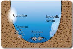
Waves erode the coastline through the processes of:
Hydraulic Action: the force of the waves crashing against the cliffs & weakening faults & widening cracks.
Abrasion: The sand & small material carried in the waves scraping against the rocks/cliffs & wearing them away.
Attrition: Rocks & boulders in the water crash into each other and break into smaller pieces.
Corrosion: The sea water dissolves soluble material in the coastline ( especially in limestone & chalk).
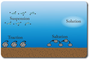
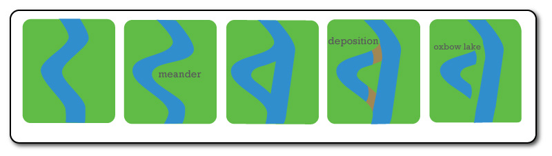
Longshore drift is the movement of material along the coastline. It occurs due to the swash bringing material up the beach at an angle The backwash then drags the material backwards into the sea & the process repeats.
Coastal Management
Wooden groynes can be built along beaches to reduce the effects of longshore drift. They do not stop it but slow it down.
Sea walls can be constructed at the back of beaches to absorb and deflect the waves energy, protecting cliffs or promenades.
Beach nourishment is the practise of bringing in extra sand to top up beaches. It is expensive and will need repeating.
Gabions are wire cages filled with rocks that serve a similar purpose to sea walls but are cheaper and can be removed easily.
Short-term/Emergency Aid: this consists of provisions given immediatlely after a disaster. Food, bottled water, medicine, shelter. By providing these things hopefully further problems such as spread of disease can be avoided.
Long-term/ Structural Aid: aid to assist in development of infrastructure, improving education & health services. These types of aid should improve the economy & lead towards self sufficiency.
Bilateral Aid: given by one country to another (may have conditions attached).
Multilateral Aid: Aid from many countries usually given through an agency such as the IMF, UN, World Bank.
Voluntary/NGO Aid: NGOs are Non-Governmental Organisations - usually charities that individuals can give aid through.
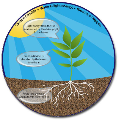
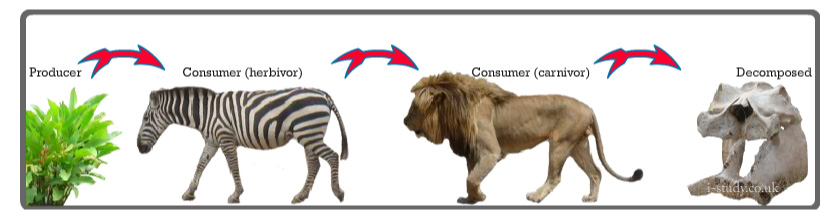
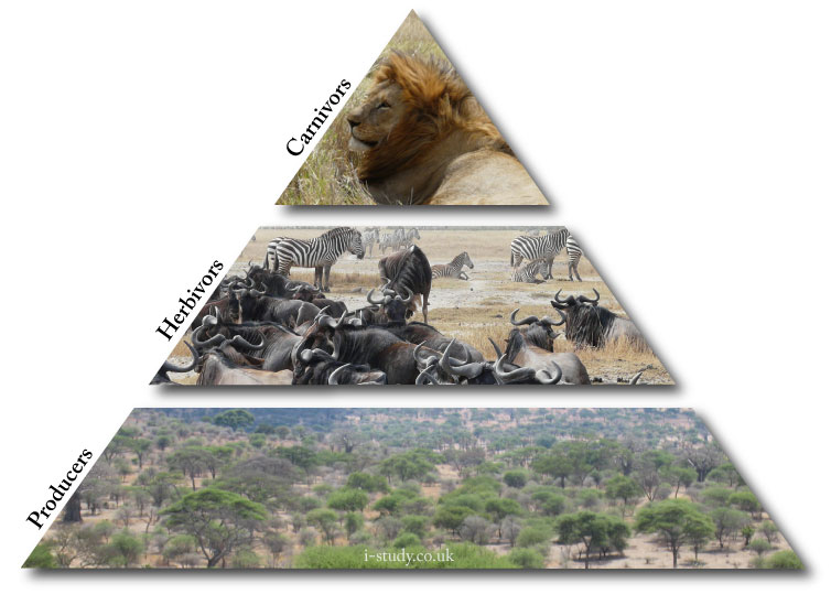
Ecosystems and all the life that exists within them rely on the ability of plants to harness the suns energy and convert it into gulcose. The energy is then transfered through the food chain and eventually recycled as animals and plants die, decompose and return the nutrients to the soil.
The plants are called producers (they produce the initial energy).
Consumers eat the producers & maybe other consumers.
Decomposers return the nutrients to the soils.
Photosynthesis also plays an important role in producing oxygen which is essential for life.
The worlds population is dependent on farming to provide our food. As the population increases there is less land available for farming but more food needed. This increasing demand is causing overuse of resources and requiring technological advances to solve the problem.
In the 1970s scientists started to adapt the genetic makeup of crops to improve global food supplies.
They produced HYVs (High Yield Varieties) which produced more grain per plant than standard crops and allowed more than one crop per year. Genetically modifying the seeds also allowed them to make them more resistant to droughts and disease.
The downside of these seeds is that they need to be purchased each year which is expensive.
The revolution was successful in MEDCs which could afford expensive irrigation and to buy the seeds each year.
In many LEDCs farmers invested in the seeds often getting into debt. They did indeed increase crops which led to the price of food falling leading to many famer’s unable repay the loan & buy new seeds for the next year.
The proportions of each of the sections that make up a total economy is known as the employment structure.
Most developed countries have experienced a decline in their secondary industries, particularly heavy manufacturing. Competition from developing countries has led to some firms closing as they can't compete with the lower labour costs in LEDCs. Other firms still remain but have relocated their factories to developing countries. They do this for several reasons:
To be closer to the raw materials, or closer to cheaper sources of raw materials. Resources have been depleted in many developed countries and where they remain the costs of extracting them is often high.
To benefit from cheaper labour costs. They may also take adavantage of less labour laws and the willingness of people to work longer hours and have less holiday das per year.
To be closer to large markets to sell their products. Increasing wealth in many developing countries with large populations (China, India, Indonesia etc) is changing the gobal market place. Many European car manufacturers sell rapidy increasing numbers of their vehicles in China and India.
Many industries in MEDCs have become much more geographically mobile. They can locate in a range of places since they are less dependent on raw materials and more dependent on skilled labour.
Many offices and ICT software/hardware companies locate on the edges of urban areas in much more pleasant surroundings. A similar trend has occured with the retail sector as shopping malls in increasingly common in the suburbs of large urban areas.
These locations are often cheaper, have plenty of space for parking and are closer to the workers/customers homes. The development of the internet has rreduced the need to be near services such as post offices, banks and other firms. Email, video conferencing, online banking and similar services allow forms to locate in more rural settings.
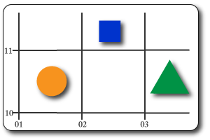
These provide a reference telling us which grid square the object is in.
Go along the bottom first & up the side second:
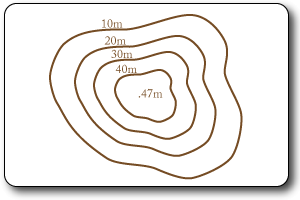
These provide more accurate location by specifying the exact location within a grid square.
As before, go along the bottom to get the square & then put how many tenths across it is (like a decimal point). Normally you will have to do this bit in your head as the only the numbered lines will be shown.
Repeat this on the verticle axis.

These are the brown lines & they run along the sections of the map that are the same height. They are given a number which represents the height above sea level in meters. The closer together they are the steeper the gradient.
These are the exact height of a point shown with a black dot & the height in meters next to it.
This technique uses layes of different colours to represent height.
A key indicates the value of the colours.
If the colours change quickly it shows a steep slope.
It provides a very visual and easy to read display of the landscape.
Population distribution is how people are spread out & this can be considered on any scale. People are distributed around the globe but the population density varies considerably.
Population density refers to hao many people live in a given area (usually km or mile square. Areas with fertile soil, good climate and reliable water supplies tend to be densely populated. Areas that have extremes of temperature, steep land, unreliable water supplies and poor soils tend to be sparsely populated.
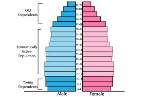
Population pyramids show the sex & age make up of a countries population and are very useful for comparing countries. The shape of a countries pyramid can give us a clue about the level of development in the country.
LEDC pyramids typically have wide bases due to high birth rates. A classic pyramid shape due to a high death rate at all ages. They are short due to relatively low life expectancy.
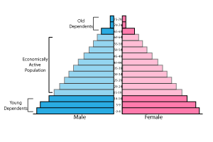
MEDC pyramids tend to be narrow at the base (low birth rate) and remain a similar shape up to the ages of 65+ due to a low death rate through these ages. The pyramid is often tall due to long life expectancy.
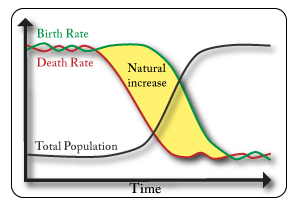
This is a model that shows how a countries population typically changes over time as it develops.
This is mmigration which occurs within countries.
LEDCs are experiencing rapid rural to urban migration as they industrialise.
MEDCs are experiencing counter-urbanisation as people move to more pleasant and peacefull locations.
This is the movement of people from the countryside to the cities.
Push factors
Pull factors
This is the movement of people out of the cities to the surrounding rural areas. The internet and telecommunications technology are changing the nature of business locations and remote working.
Push Factors
Pull Factors
This is the movement of people from one country to another to live. There are various reasons why people may migrate internationally & they can be categorised as:
Forced: when people have to leave for reasons such as: natural disasters, war, famine, political persecution
Voluntary: when people choose to leave for reasons such as: climate, jobs, education.
There are often large numbers of migrants from developing countries to developed ones as they seek higher wages and better living conditions. Some examples are Mexicans moving to the USA and Polish migrating to the UK. Migrants that send money back to their home country (remittances) play an important role in redistributing income on a global scale.

Urbanisation: an increase in the % or proportion of the population living in towns and cities.
This process happened in MEDCs as they industrialised but is now more commonly associated with LEDCs. The main causes are:
Push Factors of rural areas
Pull Factors of urban areas
Whilst these are certainly all available in cities the ability of inward migrants to access them mey be very limited.
Location: Greenwich Peninsular, London, UK
Cause: Old dock based industrial inner city area of London. Industry had closed, buildings were derelict & few job opportunities.
Effects:
Aimed at being sustainable:
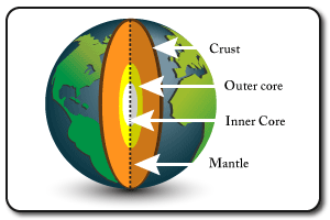
The crust is the outer layer, broken into sections called tectonic plates. It is the thinnest layer. The mantle is the thickest layer and consists of molten rock The outer core is molten & about 3000 degrees C. This inner core is solid due to the immense pressure and is about 5000 degrees C. Both the inner & outer core consist of iron & nickle.
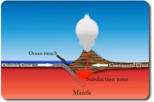
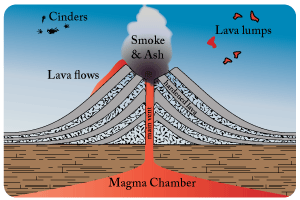
Oceanic & continental plates collide. The oceanic plate is denser and so sinks under the continental plate. As the oceanic plate sinks it takes some sand, water and other material from the sea bed with it. This melts and is gaseous which causes it to force its way up to the surface as a volcano. The continental plate crumples at the edge creating fold mountains in addition to the volcanoes.
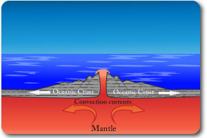
Convection currents in the mantle drag the plates apart. Magma rises to fill the gap and solidifies to form new crust. As the process repeats a ridge is formed and this slowly gets wider as the plates continue to seperate. Example: the Mid-Atlantic Ridge. This creates fissure volcanoes which are long cracks, they are less explosive.
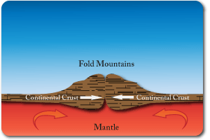
Convection currents in the mantle pull two plates of continental crust together. Since both crusts are made of the same material and have equal density neither subducts. They crumple up. This process creates fold mountains. There are no volcanoes at these boundaries but earthquakes occur. Example: the Himalayas.
The ability of MEDCs to prepare and predict more thoroughly reduces the impact of most disasters. The same is true for other natural disasters such as floods and hurricanes.
Location: Southern Honshu, Japan.
Cause: Destructive boundary (Philippines plate sub-ducting under Eurasian plate).
Effects:
- Measured 7.2 on Richter Scale & lasted 20 mins.
- 200 000 building collapsed.
- 1km of Hanshin Expressway (elevated main road) collapsed.
- Fires burned for days (broken gas pipes & wooden houses!!!).
- Severe traffic jams delayed emergency services.
- 5500 people killed. Factories closed (Mitsubishi & Panasonic).
Tourism is one of the largest, fastest growing and most important industries in the world.
It plays a role in distributing wealth between MEDC & LEDC countries and offers jobs/an income to millions of people with limited skills and education.
Tourist: Someone who travels somewhere for pleasure on short term basis.
Environmental: places with unique very attractive environments/landscapes attract many people. Safaris in National Parks such as the Serrengeti, Tanzania, East Africa are an example.
Historical: Rome, Athens and Egypt attract vast numbers of tourist interested in seeing the ancient civilisations buildings.
Cultural: countries with strong cultures such as Guatamala attract many visitors whow ish to see and experience it.
Adrenaline: adventure and adrenaline sports enthusiasts travel the world dfor sports such as mountain climbing & whitewater rafting.
Relaxing: beach resorts can be found globally and are very popular as tourists want to soak up the sun, swim in the sea & pools and fdorget about the daily routine at home.
Medical: increasing numbers of people travel to other countries to take advantage of high quality but much cheaoer medial services. Many Amercican & Canadians travel & stay in Costa Rica for medical purposes.
Rising disposable incomes: over the last 50 years people in developed countries have had increasing amounts of spare money to spend on holidays. This is now occuring in some NICs such as India, Brazil and China.
Rising populations: there are more people in the world and subseuquently more people to take holidays.
Holiday Allowance: people generally are entitled to more holidays from work, in Europe the standard is 4 weeks.
Cheaper & faster transport: the real cost of flying has fallen considerbly and it is affordable for many more people. transportation has also got much faster (flights, cars, trains) which has made destinations seem much closer.
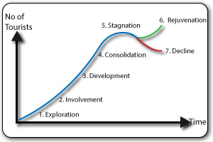
Exploration: initial discovery of a destination by a few more adventourous tourists. Likely to be very few tourist facilities.
Involvement: Local populations start to realise the potential of tourism and open hotels, restaurants etc.
Development: Large companies (hotel chains etc) start to invest in the destination & open large hotels & restaurants. This leads to rapid increases in the number of visiting tourists.
Consolidation: the destination is dominated by tourism at this point and the economy and is still growing. Services and supplies for the local population may suffer.
Stagnation: facilities and hotels age and become less attractive. Overcrowding and litter/pollution starts to put tourists off coming..
Decline or Rejuvenation: Destinations face declining arrivals if the resort continues to become run down & less attractive. This oftn leads to loss of jobs and increases in crime. Resorts may invest in regeneration and cleaning up the environment to attract new tourist again and revive the industry.
Tourism has been rapidly expanding in most areas of the world. Rising levels of disposable income in MEDCs and an emerging middle class in the NICs have led to many more people travelling.
The cost of air travel has also been falling in real terms over the last few decades as planes become much more efficient and airlines save costs through utilising technology (e-tickets, self service check in etc). This has brought financial benefits for tourist destinations.
Many LEDCs have been able to promote and exploit their natural landscapes and wildlife, from safaris in Tanzania and Kenya, Gorilla trekking in Rwanda, to rainforest trekking in Costa Rica and glacier tours in Argentina. Other countries have relied on historical and cultural attractions such as Mexico and Egypt with their pyramids, Laos with the Angkor Watt temples, Peru with the Inca ruins of Machu Pichu.
These countries have been able to attract large numbers of tourists and generate significant amounts of foreign earnings. The tourism industry employs a whole range of people and many of them are relatively unskilled - bus drivers, taxi drivers, waiters, bar staff, cleaners, tour guides and so on. Tourism can create a multiplier effect in the economy and be a good driver of growth. Tourist resorts have sprung up rapidly where there is demand, many of them being owned by MNC hotel chains. While they generate significant income they also bring a raft of problems such as loss of culture, profits being repatriated to the home country of the hotel, environmental degradation and overcrowding of the local places.
Economies that are heavily reliant on tourism face many potential difficulties. Any negative occurrence in the country can dissuade tourisms from coming (the recent troubles in Egypt have decimated its tourist trade). Economic slowdowns in other parts of the world can cause a significant drop in the number of tourist (the recent economic crisis has seen tourists from Europe plummet). Rises in the countries exchange rate can make it comparably more expensive than rival destinations and result in many people choosing not to come.
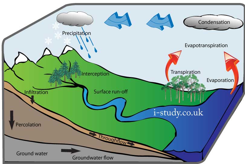
Weather is the short term conditions of the atmosphere around us, whereas climate is the longer term average conditions of a place.
Weather |
Instrument |
Measurement |
Rainfall |
Rain Guage |
mm |
Air Pressure |
Barometer |
mb |
Humidity |
Hygrometer |
% |
Wind Speed |
Anemometer |
Km/hr or Miles/hr |
Wind Direction |
Weather Vane |
Compass directions |
Temperature |
Thermometer |
Degrees C or F |
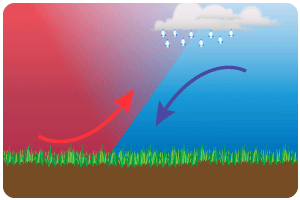
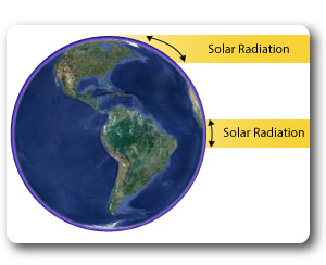
The concentration of the suns energy reaching the earth diminishes with distance from the equator. As the diagram shows, the curvature of the earth results in the solar radiation being spread over a much wider surface area at higher latitudes.
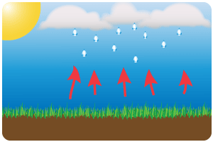
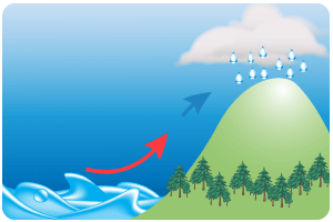
The result of this is much warmer temperatures around the equator which results in high levels of evaporation from the oceans.
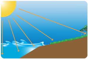
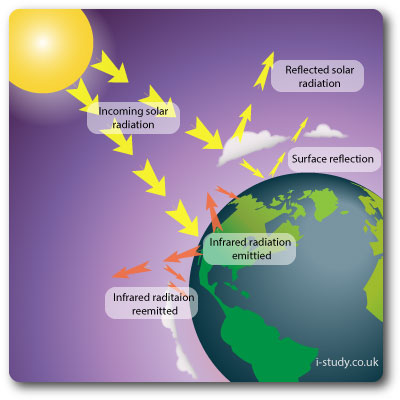
Incoming solar radiation enters the earths atmosphere. Some is reflected by clouds and some more is reflected by atmospheric pollution.
On reaching the earths surface some of the light is reflected depending on the albedo rate (ice sheets, oceans etc).
The rest is used by plants (photosynthesis) or absorbed by the land and oceans. This heats the land and oceans with the heat being released into the atmosphere as longwave infrared radiation.
The greenhouse gases trap some of this infrared radiation in the atmosphere. Increases in the levels of greenhouse gases in the atmosphere increase the amount being reemitted back in the atmosphere.